Disclosure: This blog take part in the Amazon Services LLC Associates Program and several other affiliate programs. We earn advertising fees by advertising and linking to Amazon.com and other affiliate partners. If you click on the link and purchase the item or make a booking, we will receive an affiliate commission at no extra cost for you. Thank You!
The fantastic coastal walk from Sagres to Salema is a part of the Fishermen’s Trail, a multi-day hiking route of the Rota Vicentina. The trail takes hikers along the beautiful coast of Western Algarve offering spectacular scenery, breathtaking views, and diverse landscape.
Table of Contents
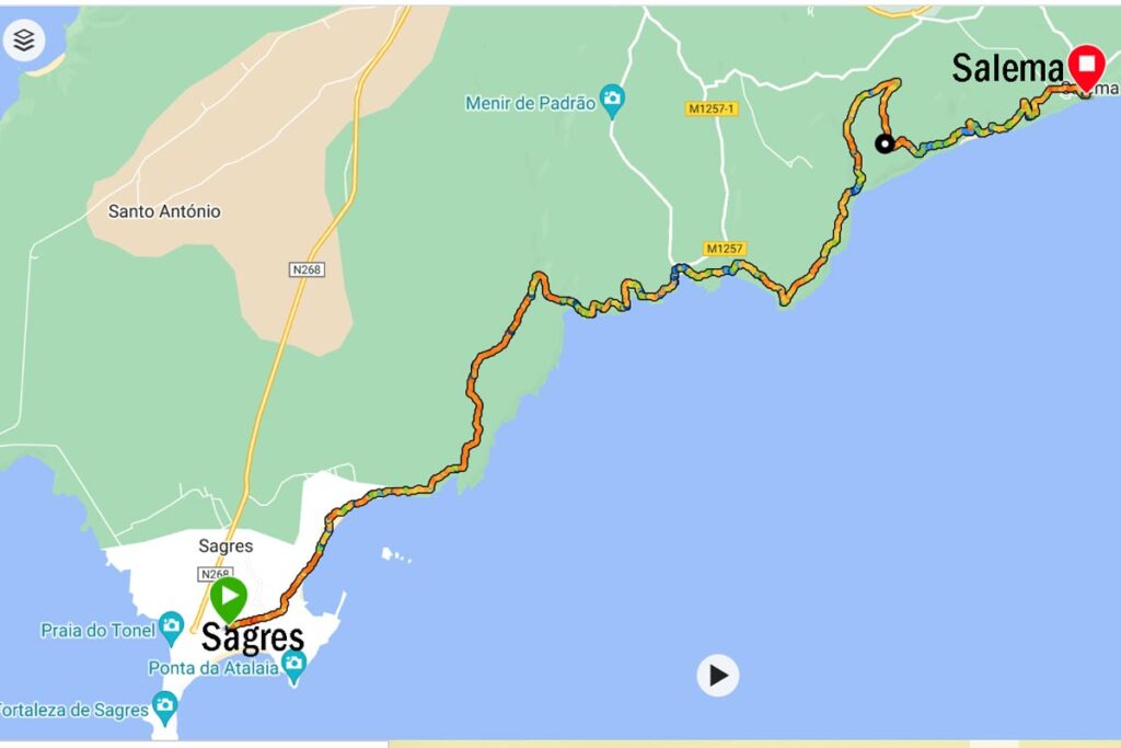
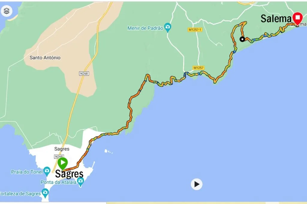
The Sagres to Salema route overview
- Total distance – 20 km/12,4 mi
- Time – 5-6 hours
- Total ascent – 533 m
- Total descent – 555 m
- Difficulty – moderate/difficult
- Starting point – the information office in Sagres
- Finishing point – the parking lot at Salema Beach
- Walking route – Sagres – Martinhal Beach – Rebolinhos Beach – Barranco Beach – Ingrina Beach – Zavial Beach – Praia das Furnas – Figueira Beach – Salema.

How long is the walk?
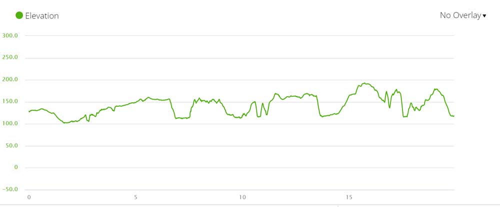
The total distance of the Sagres to Salema walk is 20 km. It takes between 5 and 6 hours on average to complete it. It will take longer depending on how much you stop. For a relaxing walk, I would suggest planning 7-8 hours that will allow you enough time to spend some time on the beautiful beaches along the trail.
Where does the route start and end?
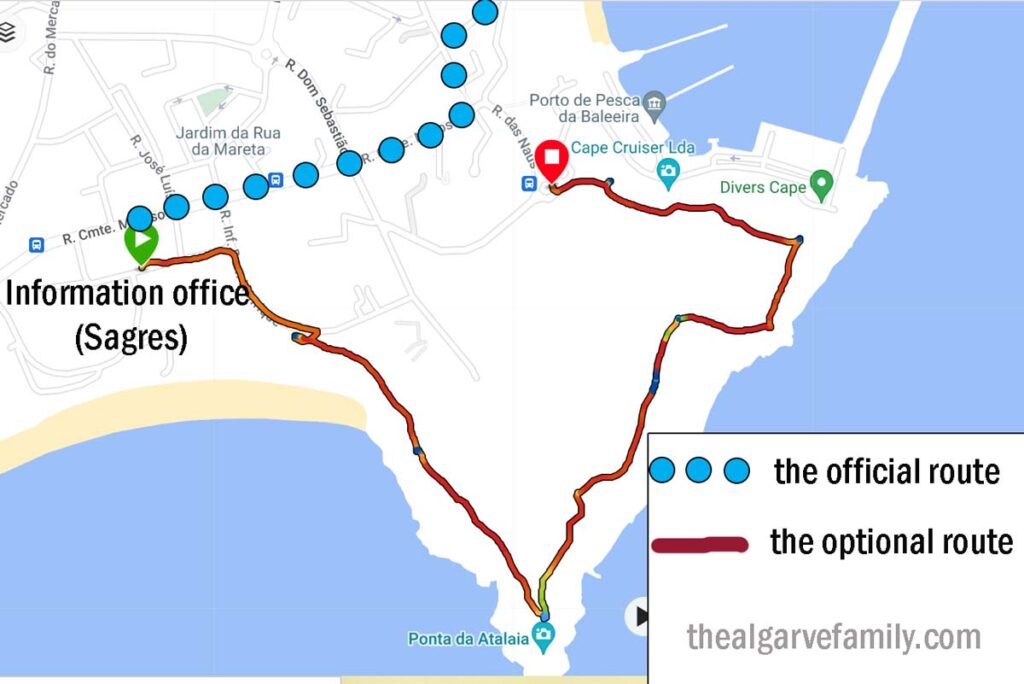
The Sagres to Salema walking trail starts at the information office in Sagres near Mareta Beach. There you can find a wooden board with a map of the trail and a sign pointing in the direction of Salema.
Instead of walking through the town, you can do a loop and from Mareta Beach walk on the top of the cliffs along the coast through the Ponta da Atalaia lookout point. It’ll add about 2,5 km to your total distance but in my opinion, it’s totally worth it. I really enjoyed the views of Mareta Beach, Sagres Fortress, and the harbour from the top of the cliffs. To get back to the official trail head to Pinóquio Café in Rua Cmte Matoso.

The trail (this section) ends at the parking lot of Salema Beach. You can continue walking on the Fishermen’s Trail from Salema to Praia da Luz or Praia da Luz to Lagos or do a trail from Vila do Bispo to Carrapateira.
How difficult is the Sagres to Salema walk?
Out of 13 stages of the Fisherman’s Trail, the Sagres to Salema walk is the most challenging especially the second half where you go up and down the cliffs all the time.

Can the trail be walked in both directions?
Yes, the trail can be walked in either direction; west to east or east to west. It’s marked both ways. I walked from Sagres to Salema. I’d say it’s better to walk the trail from Salema to Sagres because you get the challenging part of the trail at the start of the day before it gets hot and you get tired.
Is the trail well-marked?
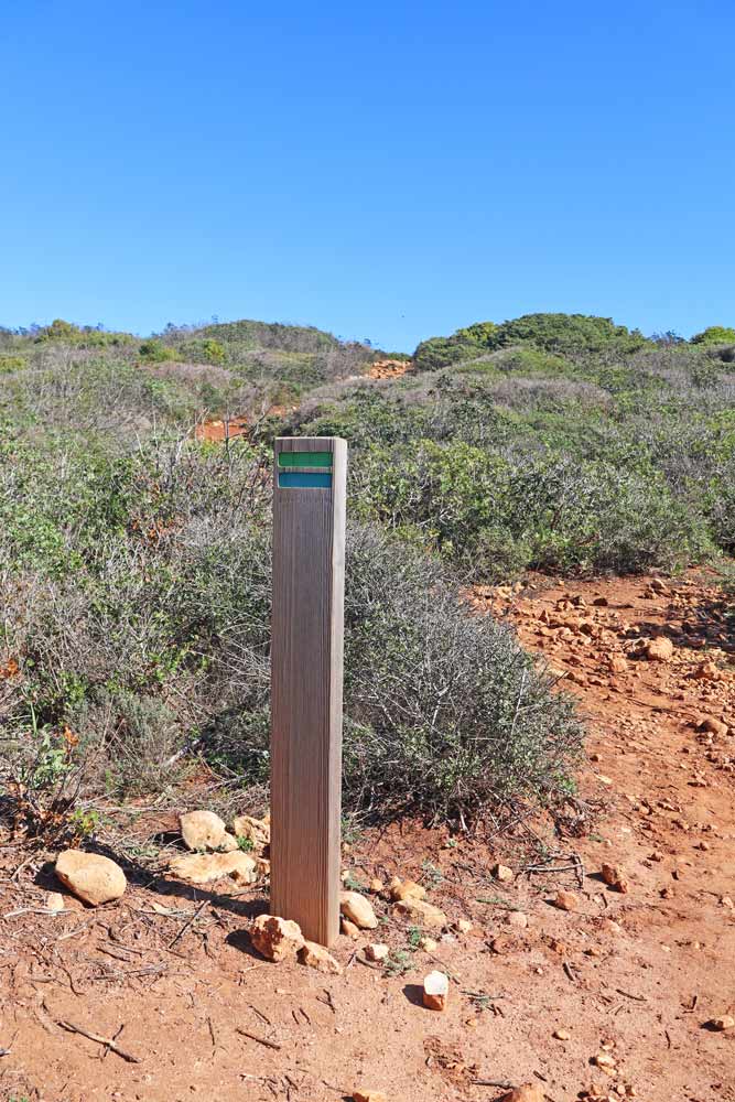
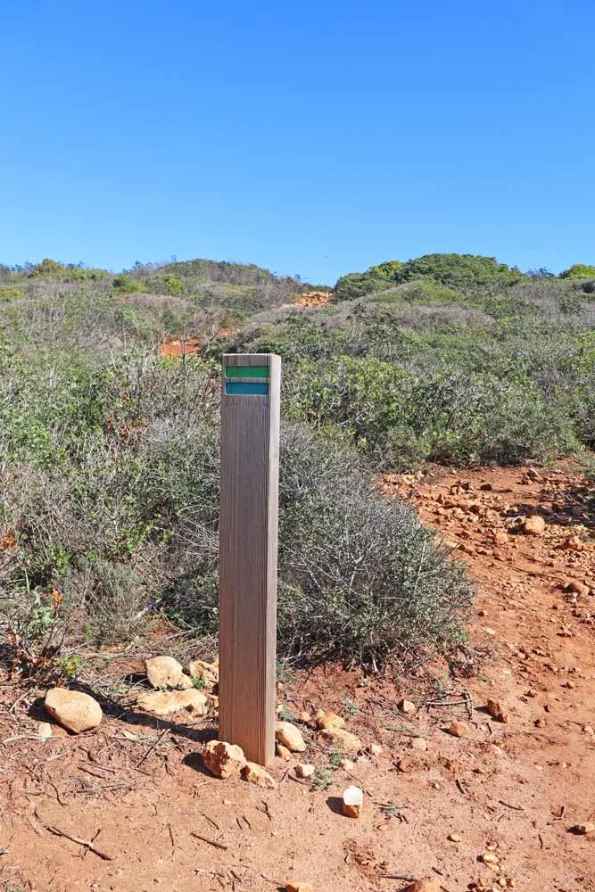
Yes, the Sagres to Salema route is well-marked with blue and green stripes painted on rocks, wooden poles, and trees. In addition, along the trail, you get wooden signs with distances to the next beach or town.
What is the scenery like?
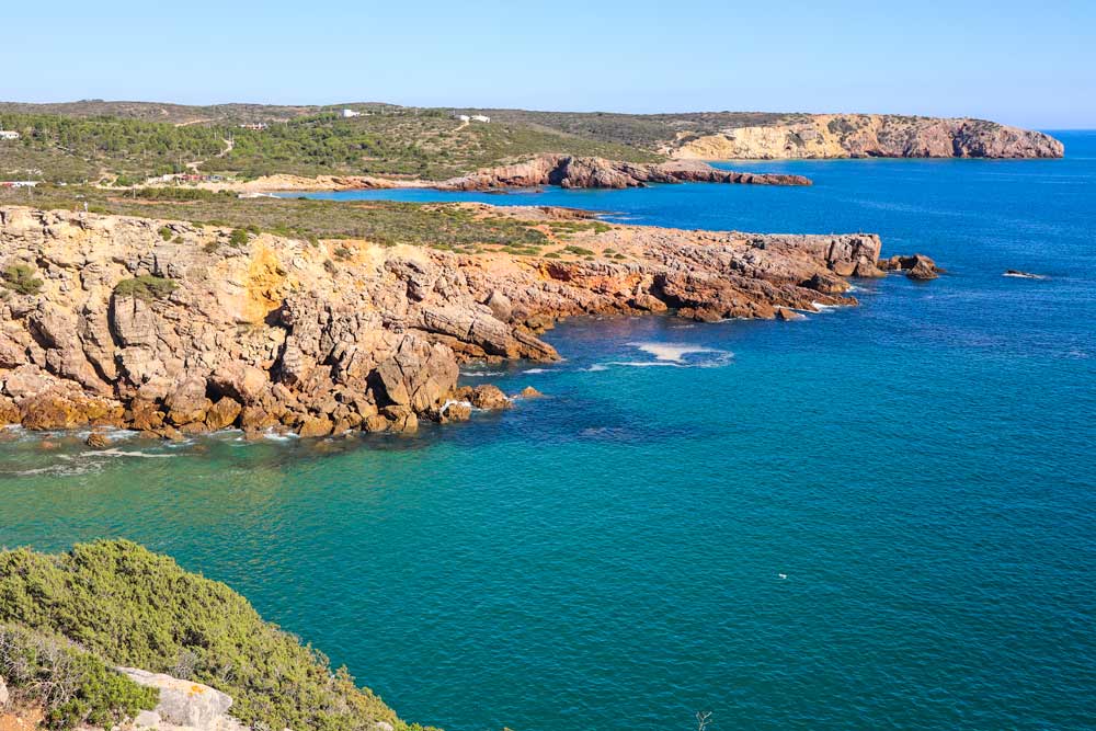
For the biggest part of the day, you walk on the top of the cliffs along the coast so you get breathtaking sea views. The route goes through many beautiful beaches, lookout points, small bays, etc. There are two short stretches on the trail that go inland that take hikers through the countryside.
What are the highlights of the Sagres to Salema walk?
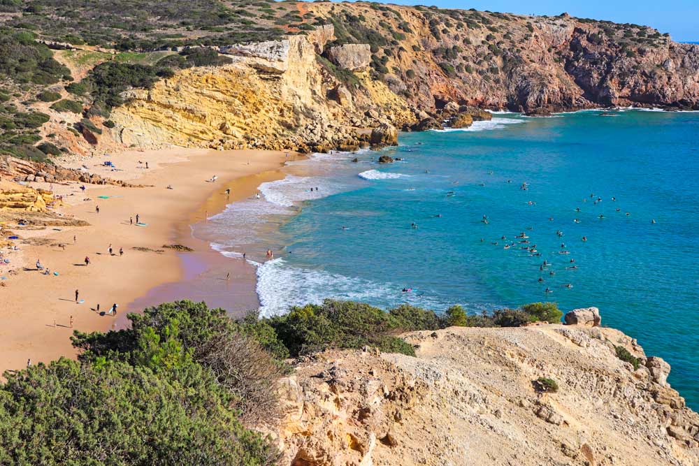
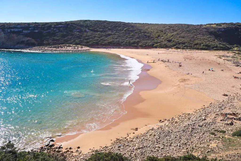
I would say that the trail is one big highlight, especially the coastal parts of it. Rugged cliffs, sandy beaches, dramatic drops, stunning lookout points, rocky pools, etc.
- Martinhal Beach
- Barranco Beach
- Ingrina Beach
- Zavial Beach
- Praia das Furnas
- Figueira Beach
- Salema Beach

When is the best time for walking?
Spring months of April and May are probably the best time for hiking in the Algarve. When it’s warm and sunny and fields along the coast are covered in wildflowers. It’s a good time for birdwatching.
Winter months are nice for walking because it doesn’t get too hot and the weather is still pleasant most of the day but you can be unlucky and get a couple of rainy and windy days.
Hiking in the summer, especially in July, August, and the first half of September you don’t have to worry about the rain at all but it gets very hot. If you decide to do the walk during these months it’s highly recommended to start early to be done before the midday heat. These months are the peak tourist season in the Algarve expect many people and higher prices.
June, the second half of September and October are good months for doing the Sagres to Salema walk. It’s usually warm and sunny and not overcrowded like during the peak summer months.

How to get to Sagres?
You can get to Sagres by direct bus from Lisbon or Lagos. Bus #47 (Vamus Bus) from Lagos departs several times throughout the day. It takes 1 hour to get from Lagos Bus Station to Sagres. The price is 3 euros. Check the current timetable here. You get off the bus at the bus stop in Sagres in front of the information office at Jardim de Sagres.
To get to Sagres from Lisbon by bus takes 4h30min. There are direct buses from Sete Rios bus station in Lisbon. The number of daily buses depends on the day of the week and season. There are more buses on weekends. The price is around 23 euros per person. You can find out more information on the Rede Expressos website.
The route map
The Sagres to Salema walk description
From the information office in Sagres, the trail follows the main street (Rua Cmte Matoso) and at the end of the street (just before Pinóquio Café) turns left following a small street (Rua Jaime Conde).
1,7 km/1 mi – Praia do Martinhal. After 300 m on the beach, the trail goes left, loops past Nortada Beach Bar and then goes back to the beach. You can walk on the beach all the way without going through the bar unless you want to stop for breakfast.

2,7 km/1,6 mi – Praia dos Rebolinhos, a small rocky beach.
Between 2,7 km/1,6 mi and 6,5 km/4 mi – the trail goes inland through the fields.
6,5 km/4 mi – a steep downhill.
7,5 km/4,6 mi – Barranco beach, a hidden sandy beach and a popular stop for campervans.
10 km/6,2 mi – Ingrina Beach, a small sandy beach with a restaurant. The restaurant doesn’t accept cards, only cash. It opens at 10 am, closed on Tuesdays.
10,7 km/6,6 mi – Zavial Beach, a popular and busy surfing beach with a restaurant. The restaurant opens at 11 am, it’s closed on Mondays. The descent to the beach from the cliffs is a bit tricky (loose rocks). The trail crosses the beach and continues along the cliffs first with a short steep ascent and then descent. You can walk on the beach instead and get to the trail at the end of it you’ll see a trail on the left going up the cliffs. It’ll save you some energy.
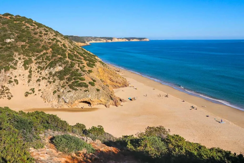
13,6 km/8,4 mi – Praia das Furnas, a nice sandy beach with a steep descent from the cliffs. From here the route goes up to the top of the cliffs and down to the beach pretty much non-stop till the end. In my opinion, it’s the most difficult part of the Sagres to Salema walk.

Between 13,6 km/8,4 mi and 16,6 km/10,3 mi the trail goes inland on the gravel road over the hills.
17 km/10,5 mi – a steep descent to Figueira Beach with a subsequent ascent to the top of the cliffs past the ruins of a small fort.
17,5 km/10,8 mi – a steep and tricky descent to Praia Santa with a subsequent ascent.
19 km/11,8 mi – first houses of Salema.
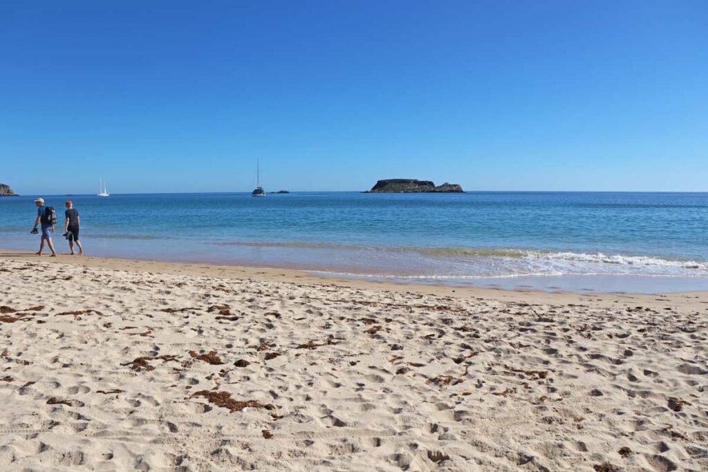
20 km/12,4 mi – Salema Beach.
What to pack for hiking?
It’s a day hike so you don’t have to carry a lot. If you walk in summer make sure to carry enough water. You can buy more water at Ingrina Beach (10 km/6,2 mi) and at Zavial Beach (10,7 km/6,6 mi). Make sure to have cash, not all restaurants and shops accept cards.
- Water bottle
- Cap/hat
- Sunglasses
- Sunscreen
- A quick-dry towel (if you’re planning to swim)
- Small 10L backpack
- GPS watch if you want to track your steps, heart rate, recovery time, etc.
Places to stay in Sagres
- Low-end | PuraVida Divehouse | Sagres Sun Stay – Surf Camp & Hostel |
- Mid-range | Tonel Apartamentos Turisticos | Aparthotel Navigator |
- High-end | Mareta Beach – Boutique Bed & Breakfast | Memmo Baleeira – Design Hotels |