Disclosure: This blog take part in the Amazon Services LLC Associates Program and several other affiliate programs. We earn advertising fees by advertising and linking to Amazon.com and other affiliate partners. If you click on the link and purchase the item or make a booking, we will receive an affiliate commission at no extra cost for you. Thank You!
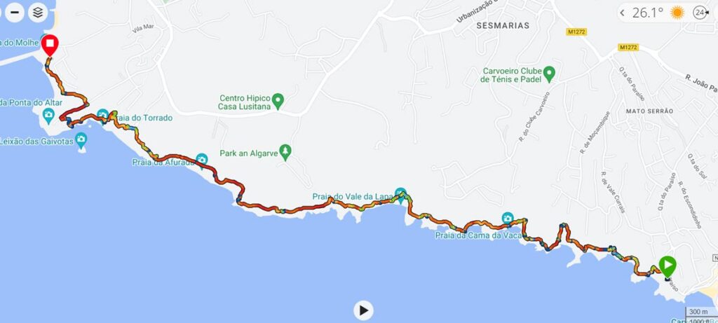
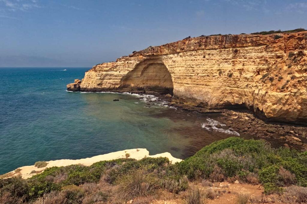
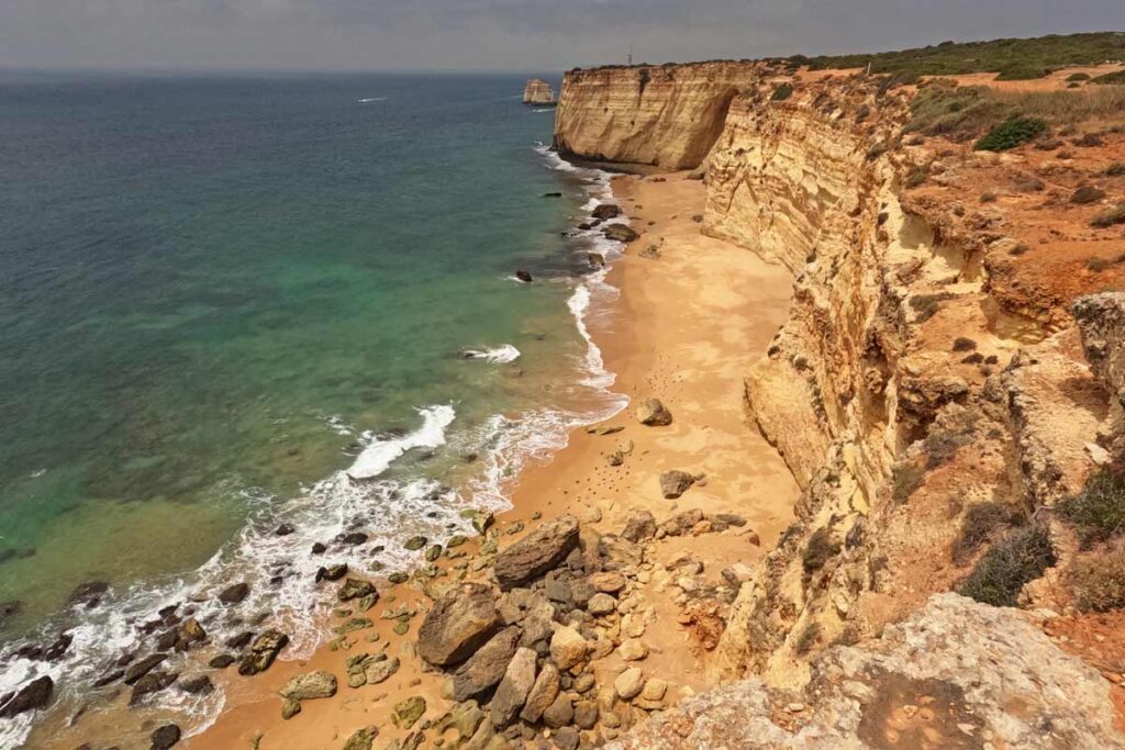
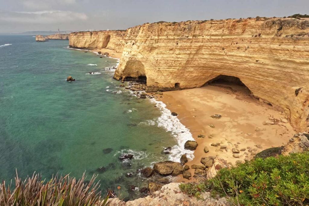
The Trail of the Headlands is a 6-kilometers coastal route that starts at Praia do Paraiso in Carvoeiro and finishes at Praia do Molhe in Ferragudo. The trail goes along the rugged limestone cliffs that the Algarve region in famous for. The scenery along the route is truly spectacular: unspoiled beaches, dramatic drops, caverns and arches, breathtaking lookouts, and the turquoise sea.
Table of Contents
Trail of the Headlands overview
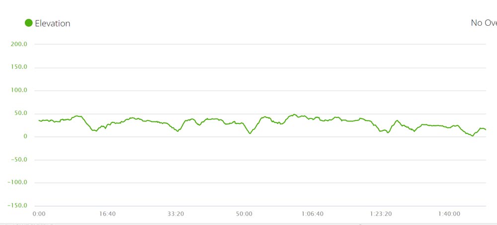
- Total distance – 6,5 km/4 mi, one way
- Time – 2 hours
- Accumulated ascent – 227 m
- Accumulated descent – 243 m
- Starting point – Praia do Paraiso, Carvoeiro
- Finishing point – Praia do Molhe, Ferragudo
If you come to the area make sure to visit the Benagil Cave, one of the highlights of the Algarve region. The best way is to do a kayak tour from Benagil Beach. It’s possible to visit the cave with a boat tour from Lagos or a catamaran tour from Albufeira in this case you’ll be able to see the rugged coast of the Algarve from the sea.
What is the trail of the Headlands in Portugal?
The trail of the Headlands is a linear coastal walking route in the Algarve region of Portugal. The trail follows the rugged coast offering spectacular scenery. It’s a good alternative to the famous Seven Hanging Valleys Trail if you want to walk a trail with fewer tourists.
Where does the route start?
The trail starts at the parking lot of the Praia do Paraiso (Paradise Beach) in Carvoeiro. At the entrance to the parking lot, you’ll see a board with a map and the information on the trail. From there the route goes along the cliffs past Mar d’Fora restaurant. The parking lot is not very big if you want to leave your car there it’s advisable to come early in the morning to make sure you get a spot.
The restaurant opens only at 12.30 pm if you want to have breakfast before starting the walk you’ll have to find another different place.
If you start the hike in Carvoeiro don’t forget to visit some of the famous local attractions; the Carvoeiro boardwalk, Algar Seco, and Carvoeiro Beach.

Where does the trail end?
The trail of the Headlands ends at Praia do Molhe in Ferragudo. There is a nice restaurant O Molhe at the end of the route where you can have lunch or snack.
How long is the Trail of the Headlands?
It’s a 6-kilometres linear route. You can walk only one way or do a return hike then the distance is 12 km.
Can be the trail walked in both directions?
Yes, you can walk the Trail of the Headlands west to east (from Carvoeiro to Ferragudo) or east to west (from Ferragudo to Carvoeiro). The route is marked both ways. It’s difficult to say which way is better. The views are amazing in both directions.

How difficult is the Trail of the Headlands?
It’s an easy-moderate route. The distance is short which makes it quite easy but multiple ascents and descents on the trail make it more challenging especially on a hot summer day.
We wanted to hike the trail of the Headlands with our 1-year-old daughter carrying her in a Deuter hiking carries but, in the end, I walked alone. I’m glad we didn’t carry here. There are many short descents with loose rocks that are a bit tricky to walk carrying a child on your back. If you’re looking for a coastal trail to walk with a child in a back carrier I can recommend hiking from Praia da Luz to Lagos. The Ludo Trail in Faro and Alvor boardwalk near Portimão are two perfect routes for walking with a stroller.
If you’re looking for an easier walking route I can suggest boardwalks at Ponta da Piedade in Lagos. The views are just as spectacular but the walk is much easier.
How to get to the trailhead?
Driving is the easiest way of getting to the trailhead. You can park your car for free at the start of the trail at the Praia do Paraiso parking lot. If you don’t have a car you can get to Carvoeiro by bus from Portimao or Lagoa. Buses stop in Carvoeiro but not at the Praia do Paraiso. From the bus stop, you can walk or take an Uber/taxi to get there. It’s a couple of kilometres.
There is no train station in Carvoeiro. Overall Carvoeiro has a limited public transport connection with the rest of the Algarve. If you’re planning to stay there it’s definitely better to have a car. You can rent a car at Faro Airport on arrival.
After completing the trail to get to your car you can either walk back or take an Uber. It’s a very short ride that will cost you around 5 euros. If you don’t have an Uber app and don’t want to install it you can get a taxi back. It might cost you 1 or 2 euros more.
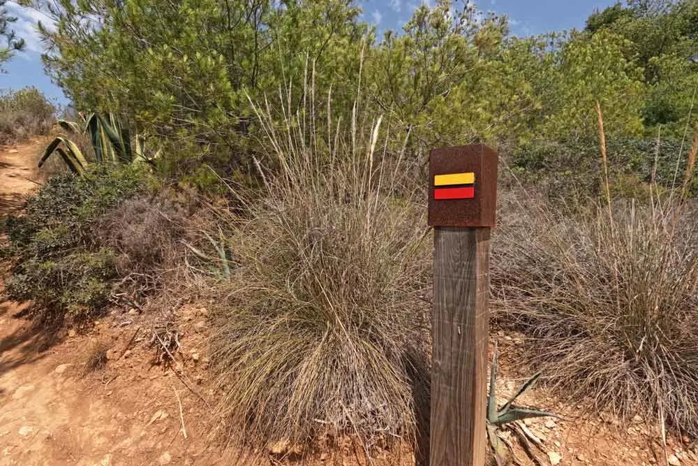
Is the route well-marked?
Yes, the route is marked with red and yellow stripes painted on the wooden poles. At the beginning of the route, the first 500 m there are wooden poles without route markers but it’s still quite easy to follow.

When is the best time for walking?
The trail of the Headlands can be walked all year round. Though in July and August daily temperatures in the Algarve reach 35°C it’s highly recommended to start hiking early in the morning, carry enough water and use sun protection. I wouldn’t advise walking the trail on a very windy day.
What are the highlights of the Trail of the Headlands?
I’d say the scenery on the trail is one big highlight. The route follows the rugged limestone cliffs for the entire 6 km which means you have breathtaking views at every moment on the trail. Here are some of the highlights
- Praia do Paraiso is a small secluded beach accessed by a long staircase
- Praia de Vale dos Currais is a nice beach with few people 500 m from the start of the trail that can be accessed climbing down a metal ladder
- Arriba da Salgadeira viewpoint
- Praia dos Três Castelos is another secluded beach with difficult access climbing down the cliffs and a metal ladder.
- Praia da Cama da Vaca is a beach accessible only by boat
- Torre da Lapa – a cylindric watchtower
- Praia do Mato is another beach accessible by boat. I’ve read that some people managed to climb down using ropes etc. There are plenty of beaches with easy access in the area I don’t think it’s worth the effort and risk.
- Praia da Abufada is a long sandy beach that can’t be accessed from the land. The view of the beach from the cliffs is spectacular.
- Praia dos Caneiros is a blue-flag beach with umbrellas and beach chairs for rent during the summer season.
- Ponta do Altar Lighthouse

Trail of the Headlands route description
The route starts at the parking lot of the Praia do Paraiso you’ll see a footpath along the cliffs past Mar D’Fora restaurant. Just past the restaurant, there is a wooden fence that you have to go around. There are a couple of wooden fences blocking the trail like that one in the first part of the route. I’m not sure what is their purpose but you have to go over or under them to continue walking. There are no warning signs or anything like that. My guess is that those fences stop people on bicycles and maybe even motorbikes from accessing the trail.
I walked the trail of the Headlands on Sunday morning (late morning) in mid-July and was surprised by how few people I saw there compared to thousands of tourists at the famous Benagil Cave which is just 5 km away. There are several beaches along the trail but most of them can be accessed only by boat. If you want to relax on the beach you can stop at Praia do Paraiso, Praia de Vale dos Currais, Praia dos Caneiros, or at one of the beaches in Ferragudo at the end of the route.
Between Praia do Paraiso and Praia dos Caneiros (pretty much the entire length of the trail), there are no restaurants or places to stop for food or drinks. It’s important to take enough water with you.
The trail ground is a rocky footpath with some loose small rocks that make it tricky to descend. The route goes along the cliffs sometimes it gets quite close to the edge (especially in the beginning) if you suffer from vertigo it’s not the best trail for you.
Dangerous areas where the rock formations are fragile are marked with signs if you stick to the official route you’ll be safe.
What to pack for the hike?
For a short day hike, you don’t need many things. Take a small backpack with essentials.
- Water bottle
- Cap
- Sunglasses
- Running shoes
- Sunscreen
Where to stay near the trail?
Carvoeiro and Ferragudo are the two nearest to the trail towns.
If you’re going to stay in Carvoeiro keep in mind that it’s not the best place for an extended stay if you don’t have a car. In my opinion, Lagos is one of the best towns in the Algarve to stay without a car. You can walk to supermarkets, beaches, Old Town, restaurants, etc. There are more things to do in Lagos than in Carvoeiro or Ferragudo.
Carvoeiro
| O Quintal Guesthouse | Vale d’El Rei Hotel & Villas | Quinta Nova Vale Del Rey | Monte Santo Resort |
Ferragudo
| Agua Hotels Riverside | Hotel Rural Brícia Du Mar | Vitor’s Village |
Ian Wheeler
Thursday 23rd of May 2024
Hi Guys, thanks for your wonderful advice, I’ve recently done the trail from Salema to Lagos, and now today the Trail of Headlands - it’s badly eroded from the Carvoeiro end with detours and poor signage, the various wooden fences are basically to block any access past the restaurant and a road detour is recommended to bypass the first 3 coves, hope this helps(and I have bought you a coffee!!) rgds Ian