Disclosure: This blog take part in the Amazon Services LLC Associates Program and several other affiliate programs. We earn advertising fees by advertising and linking to Amazon.com and other affiliate partners. If you click on the link and purchase the item or make a booking, we will receive an affiliate commission at no extra cost for you. Thank You!
Ludo Trail is a day hiking route through Ria Formosa Natural Park in Faro, Eastern Algarve, Portugal. It’s a popular route for walking, running, and cycling. The trail goes through the wetlands of the São Lourenço river, saltpans, and pine and eucalyptus forest.
Table of Contents
How long is the Ludo Trail?
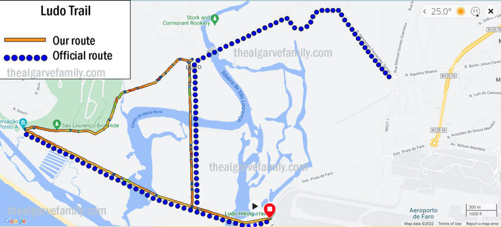
Ludo Trail is a 7-kilometre circular route (our route). It takes 2 hours to complete it. On the official map (that you can see at the start), the hike is not a circular route but rather a group of linear trails. In order to complete it, you have to walk to and back the same way. If you do so the total distance of the route is around 13 km. We walked the Ludo Trail as a circular route starting and ending at the same place but you can walk it as a linear route.

It’s possible to extend the trail by adding the Loulé boardwalk that merges with Ludo Trail at 1,6 km. It’s a 4-kilometer boardwalk that ends at Praia do Garrão. You don’t have to walk all the way to Garrão Beach you can walk as far as you want, turn around, and walk back.
If you enjoy hiking and are planning to spend some time in the Algarve don’t miss the Seven Hanging Valleys Trail and the Trail of the Headlands. These two spectacular coastal hikes offer some of the best sceneries in the region.
Where does it start?
The starting point of the trail is in Estrada Praia do Faro, between Faro Beach and the airport. It is marked on Google.maps as Ludo Hiking Trail. At the start of the trail there is a gate. The trail can be accessed 24 hours. There is not closing time. The access to the trail is free.

How to get to the Ludo Trail?
Driving is the easiest way of getting there from anywhere in the Algarve. For navigation, you can put Ludo Hiking Trail or Parque de estacionamento da Praia de Faro (the nearest parking lot) in your GPS. You can park your car at a free parking lot 500 m south of the starting point on the left-hand side. It’s a big parking lot with open spots even during the peak season.
It’s possible to get to Ludo Trail from Faro by public transport. Buses #14, #16, and #17 connect the city with Faro beach. #14 and #16 routes start at the bus station in Faro, and #17 starts at Penha. Buses make several stops in the city. You can check departure times and routes on the official website. To get to the starting point you should get off the bus at the Ludo stop, one stop before the beach. Buses leave regularly throughout the day from 7 am to 10 pm. A one-way ticket costs 2,3 euros.
Before we bought a car we used Uber quite often to get around. You can take an Uber from Faro to the trail. Depending on the season and time it’ll cost you between 6 and 8 euros one way.

How difficult is the trail?
It’s an easy trail suitable for anybody. There are no ascents or descents on the route. It’s a pleasant walk to enjoy the scenery.
What is the terrain like on the Ludo Trail?
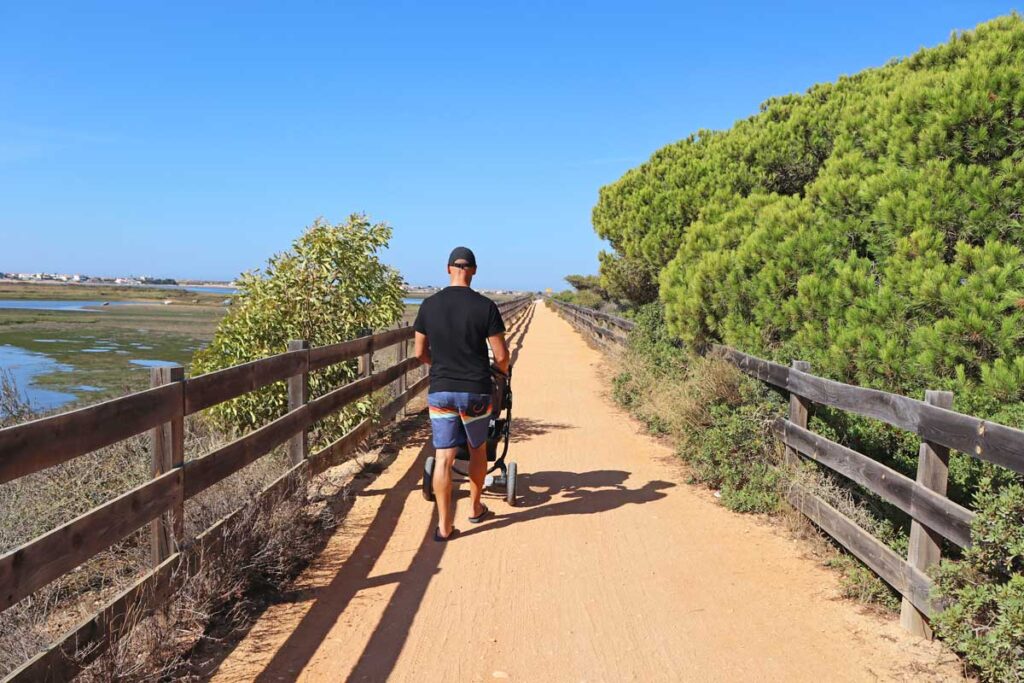
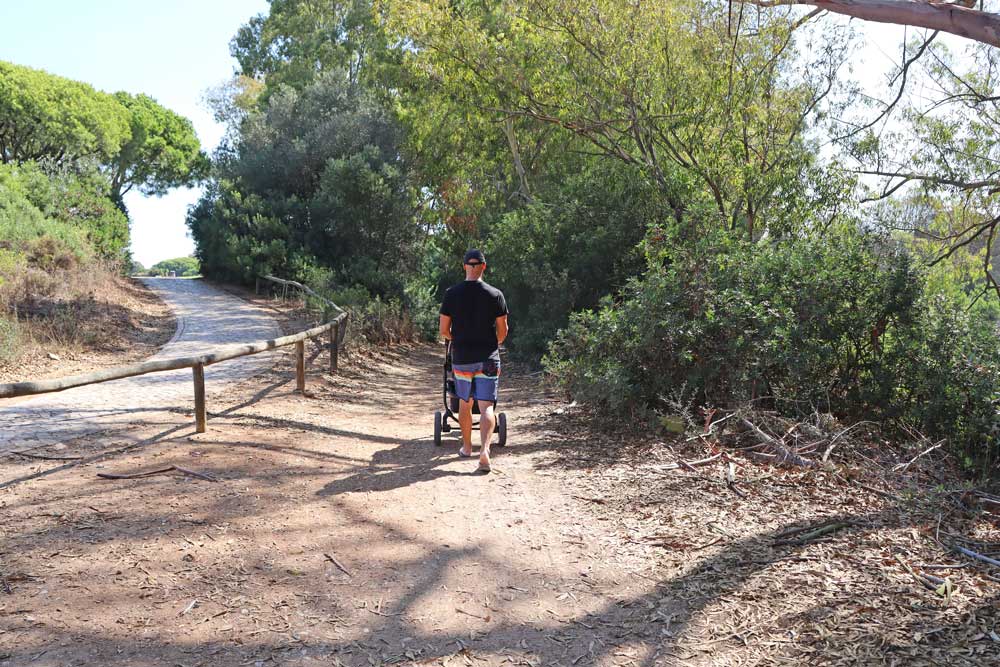
It’s a flat gravel road with no hills. The trail is suitable for bicycles, baby strollers, and wheelchairs. We walked Ludo Trail with our 1-year-old daughter in a stroller and it was very easy. It’s a popular cycling trail when we walked we saw more cyclists than hikers.

When is the best time for hiking?
Ludo Trail can be walked all year round. During the summer months (May to September), it’s advised to start hiking early in the morning to beat the heat. There is no to very little shade on the trail hikers are exposed to the sun at all times. During colder months you can walk the trail at any time. Early morning (just after sunrise) or evening (before sunset) is the most beautiful time for hiking.
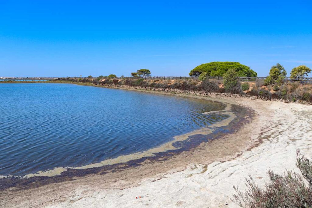
What is the scenery like?
The scenery on Ludo Trail is truly diverse marshall areas, forests, and saltpans. In short 7 km you get to see a lt of different landscapes and natural habitats. It’s truy amazing how the scenery changes every time you make a turn.
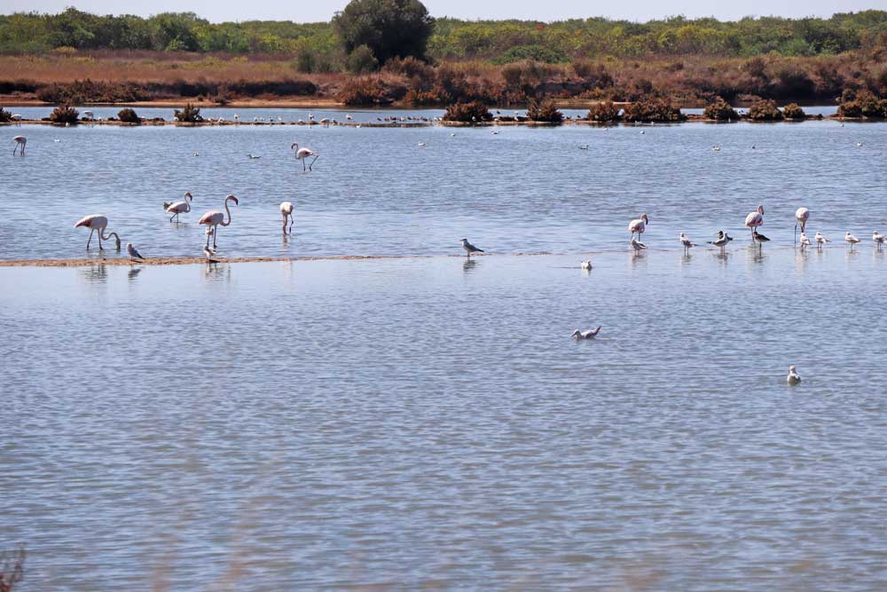
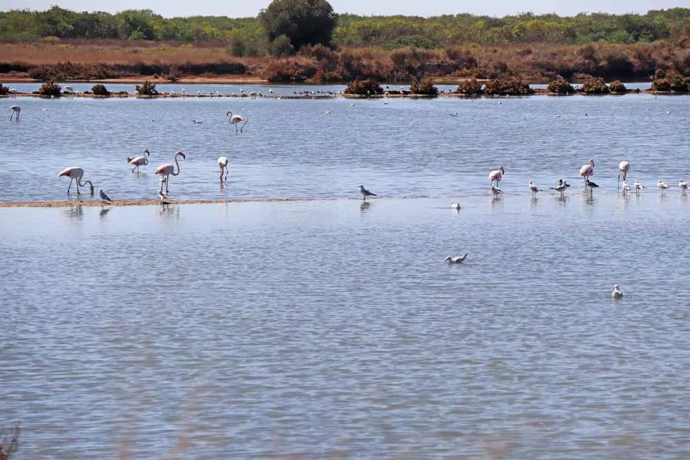
The area that Ludo Trail goes through is a real paradise for bird-lovers. Walking the trail you can spot different species of birds flamingos, storks, Black-winged stilts, and a variety of ducks. You’ll need a binocular as sometimes birds are quite far. It’s possible to see some animals as well such as hedgehogs, chameleons, frogs, and tortoises (we saw one).
Due to its proximity to the airport in the first half of the trail, you can see planes landing or taking off from close by. It gets quite noisy when a plane flies above you. It doesn’t seem to scare birds though.
Ludo Trail route description
Ludo Trail is a circular route though the beginning and the end (600 m) are the same.
Part 1. The wetlands
Between 0 km and 2,6 km
It’s the busiest part of the trail with many cyclists. The route is surrounded by bodies of water on both sides it looks like a long bridge. Walking you can see many fresh and saltwater birds.

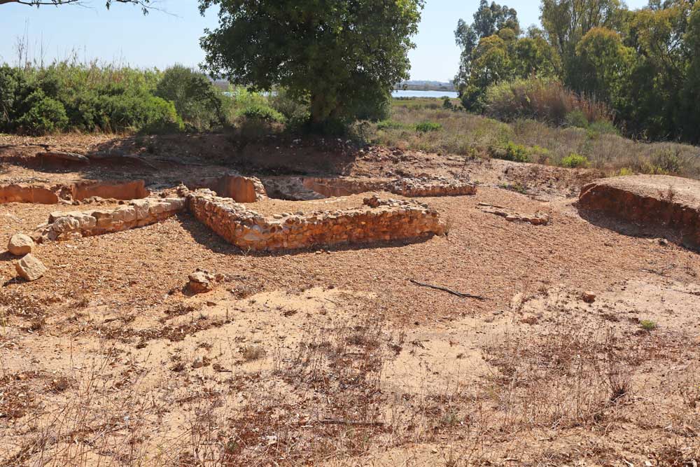
Part 2. The forest (São Lourenço Trail)
Between 2,6 km and 4 km
In this part, the trail goes through the pine forest with occasional eucalyptus on the right and golf courses on the left. The route follows São Lourenço Trail. It’s a shady part of the walk. Here you can see small Roman ruins – the remains of what used to be salting tanks. These tanks were used by the Roman to salt fish.

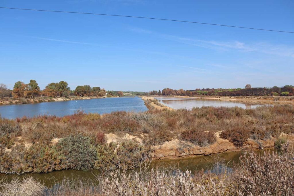
Par 3. Saltpans
Between 4 km and 6,5 km
Walking through the salt flats you can see many flamingos and seagulls sometimes from close by. Because of its unique scenery (salpans and flamingos) this part was our favorite. At the beginning you walk past “mining area” where salt is collected. On week days expect to see some machinery working.
Note! At around 5 km there is a split. The right route through the saltpans is the one to follow. It will lead you back to the entrance. The left route is marked on the official map and Google.maps as the Ludo Trail but it doesn’t go to the starting point of the trail. It ends in the suburban area of Faro, north of the airport. From there it’s about 2,5 km on the road to the starting point of the trail and the parking lot.


What to take on the hike?
- Drinking water is very important especially during the hot summer months. There will be no place along the trail to refill or to buy water. Bring 1l per person.
- Sunglasses
- Cap
- Sunscreen
- Comfortable footwear for walking. We walked in our flip-flops. Living in the Algarve that is what we wear most of the year for us they are more comfortable for walking than trail runners or hiking shoes.
- Binocular if you want to observe birds.
Nick Shaw
Wednesday 20th of March 2024
Hi, we did the Ludo Trail following your route plan and it was fantastic, thx for providing the information. We did the trail anti-clockwise and when we got to the point to turn left across the salt pans (by the salt mounds) there were lots of private property/no entry signs. We did ignore them to continue our walk. Also, when reaching the Sao Laurenco trail at the golf course we were greeted by a mesh fence and more no entry signs. We were unsure what to do until someone local came and actually cut a hole in the mesh to get through - so we followed him ! I guess this is all new but thought you should be aware of it
algarvefamily
Thursday 21st of March 2024
Hello Nick. Thank you for the comment. We did the Ludo Trail last year and there was no fence or any signs. It must be a new thing. We might drive there sometime to check it out. All the best
Marleen
Friday 6th of October 2023
At a certain point you have to cross a fence next to the golfcourt to get to the saltpans. As I did the trail in the other direction, I first missed this whole in the fence. But it was still possible. A beautiful trail with a lot of hits of different birds and crabs...